

by Dave Roberts
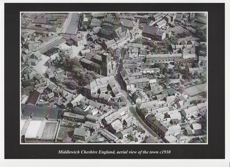
We're grateful to Dave Griffiths who contacted us in September this year with the news that a set of four aerial views of 'Middlewich in the 1930s' was being offered for sale on Ebay.
Dave couldn't resist the temptation, and bought all four photos.
He's kindly sent us copies of them so that we can show them to a wider audience and give people just a taste of how Middlewich looked no less than eighty-eight years ago (or more).
We've already encountered a couple of these photos over the years, but never before in such high quality.
English Heritage's Britain From Above website*, which features aerial photos of towns and villages all over the country, carries copies of at least two of them and, a few years ago appealed for people to contact them with information as to what they showed.
Which is what the Middlewich Diary did in respect of the Webb's Lane/Finney's Lane view (see below).
You'll note that these views are all labelled 'c1930' and this is an approximation which we'll gladly go along with for a couple of these photos. But for two of the photos we think the date may be earlier than that, for reasons we'll explain as we go along.
And so to the first photo (above). Nearly ninety years on (or perhaps even more), but still recognisable as the Middlewich we know today. Our reference point, as always, is the Parish Church of St Michael & All Angels.
We sometimes hear complaints - and tend to agree with them - about the number of trees in the churchyard today, tending to obscure the building itself from some viewpoints.
We sometimes hear complaints - and tend to agree with them - about the number of trees in the churchyard today, tending to obscure the building itself from some viewpoints.
This old photograph shows us that this is nothing new. It should be remembered that at the time of the photograph the churchyard had been disused as a graveyard for many years, the last burials taking place in the 19th century.
So the grounds of the church were, apparently, being left to their own devices at this time.
So the grounds of the church were, apparently, being left to their own devices at this time.
The triangular cluster of buildings in front of the church, comprising the old town hall and various shops, was swept away in the early 1970s to make way for first the much-hated 'Piazza' and more recently, in 2005, the 'Amphitheatre'.
The other main change, of course, is the loss of the old Town Bridge and its replacement by a much wider and larger concrete bridge, followed forty years later by the re-alignment of Kinderton Street and the building of St Michael's Way, cutting a huge swathe through the property on the left hand side of the picture.
But most people, of course, will want to know how this photo relates to what can be seen today, and this is probably best achieved by use of a numbered key.
* Unfortunately, at the time of writing, the Britain From Above website seems to be inaccessible.

1: The old town bridge. A traditional 'hump-backed' canal bridge dating back to the building of the Trent & Mersey Canal in the 1770s. Several buildings clustered around the old bridge including the Navigation Inn. The bridge was demolished in 1931 to make way for the present bridge.

The old town bridge, circa 1914. The Navigation Inn can be seen
in the middle of the photo.
2: Seabank. A road which ran (and still runs) from Kinderton Street down to the banks of the River Croco and the T&M Canal. The footbridge seen here follows the original route from Kinderton into Middlewich (before the coming of the canal there was a ford across the River Croco at this point).
In medieval times, salt houses belonging to the Barons of Kinderton were clustered around this area. The remains of the footbridge, which disappeared when the new town bridge was built, can still be seen in the form of blue-brick abutments on both sides of the canal.
The building just below the footbridge is a canal warehouse, part of the Middlewich Town Wharf group of buildings. The only other surviving building now is the Wharfinger's Cottage below the warehouse and slightly to the left.
The people of Middlewich would dearly love this area to be developed and turned into an attraction for the many boaters and other visitors to the town each year.
There have been suggestions that the buildings could be used as restaurants, museums, laundry facilities for boaters and so much more.
Unfortunately the whole idea of developing the area as the 'Gateway To Middlewich' seems to be blocked by whoever it is who now owns the land.
No progress has been made in bringing the idea to fruition and the buildings are steadily getting more dilapidated with each passing year.
3: The huge buildings fronting onto Lewin Street shared this site, between the road and the canal, with Seddon's Wych House Lane Salt Works and its associated wagon repair shop. The main buildings were the Church of England Infants' School and the Wesleyan Methodist Chapel.
Everything on the site was swept away during the 1970s and 1980s and the site is now occupied by the Salinae Centre and its grounds.
4: Across the road was another large building, and one we haven't yet covered in the Middlewich Diary, due to a lack of information. The Congregational Centenary Sunday School (below) shared this site with the Conservative Club and Heathcote's Cafe.
There was a chronic shortage of space in Middlewich's schools after the First World War and the Sunday School was used as an 'overflow' for the CofE School across the road.
In the late sixties this building was used as the local valuation office.
Middlewich Library now occupies the site.

5: Lower Street and Hightown. Now occupied by the 'amphitheatre', with the war memorial on a strip of land between the amphitheatre and the churchyard.
The original site for the memorial, erected in 1934, was at the apex of the triangle formed by these buildings, replacing a shop which did service both as a butcher and as a branch of the National Provincial Bank. Oddly, though, the bank preceded the butcher's shop. For some reason, I'd always assumed that it was the other way round. The whole area is also known as 'the Bull Ring'.
The angled building at the rear of the site is the old Victorian town hall. When the new town bridge replaced the old in 1931, Lower Street was widened by slicing off a section of the old churchyard. The part of the town hall fronting onto Lower Street was also removed to enable this work.
A section of what was Lower Street survives in the form of the lay-by used by buses and taxis in front of the 'amphitheatre'.
6: This is where we tentatively part company with the date of 'c1930' for this photo. According to all the information we can gather, the butcher's shop on Hightown which we immortalised as The Butchered Butcher's Shop and which is now a Chinese takeaway, was built in 1920 (the same year as the Alhambra Cinema, local 'historians' might like to note) but there's no sign of it here. It is, however, possible to see that one of the buildings on Hightown has recently been demolished, and we think it's possible that this is the site of the butcher's shop. If this is correct the shop to the right of the demolition is the site of what was until fairly recently the NatWest Bank (Allan Earl in Middlewich 1900-1950 (Cheshire Country Publishing 1994) mentions that in 1920 '...the construction of the new bank in the Bull Ring was well on the way').
So that would put the date of this photograph a decade earlier at c1920.
So that would put the date of this photograph a decade earlier at c1920.
If you think we're wrong, we'd love to hear from you.
7: Queen Street. The old police station. Like so many old Middlewich buildings this disappeared in the 1970s, to be replaced by a small brick box looking like many other identikit stations around the country.
Note the terraced houses stretching from the police station towards Hightown. In the street's days as 'Dog Lane' many more tiny cottages were to be found here.
8: The oblong tanks are salt pans and are part of Seddon's Pepper Street salt works. Unlike most such pans, they're out in the open air and they were used for the making of fishery salt, used in the preservation of fish and meat.
9: The site of Cooper's (formerly Kinsey's) shop. Approximately the site of the current Tesco Express store.
10: Brown's Vaults (now simply 'The Vaults') and Dewhurst's butcher's shop.
At the very end of Pepper Street which, at that time, connected Middlewich town centre with Webbs Lane. Until the early 1970s The Vaults was hidden away behind Dewhurst's, which was demolished to make way for the current pub car park.

The same view from a slightly different viewpoint. More of Seddon's Pepper Street works can be seen in the left foreground with the Trent & Mersey Canal which served it on the extreme left. Pepper Street can be seen running past the works in the middle foreground.
Towards the top left you can see the cluster of buildings around the old town bridge, then the Seabank footbridge.
Just above and to the right of the footbridge is Seddon's Wych House Lane works. and, right at the top, the bottom lock of the Brooks Lane flight.
Top right, Lewin Street continues, to become Booth Lane on its way to Sandbach.

Pepper Street, early 1969.

Finney's Lane and Webb's Lane. We have already covered this photo in the Middlewich Diary and full details can be found here. You'll note that when we originally published this we took an educated guess at the photo dating from the 1920s. Could it be that this photo, too, is earlier than we first thought?

This one is new to us and is very much of interest because it shows the Electrolytic Alkali Works in Booth Lane, the site of which has very controversially been in the news in recent years as the home of Cheshire East's new waste recycling facility. If this photo was indeed taken in 1930 the works must have just closed.

(Photo: Cheshire Image Bank)
This was one of the sites that Edwin Richard Foden looked at in 1933 for the manufacture of the E. R. Foden diesel-engined lorry, better known as the E.R.F.
So the Sun Works, Sandbach could very easily have been the Sun Works, Middlewich, had things turned out differently.
As it was, of course, the site became a pottery works owned by Steventon's and later Ideal Standard, manufacturing bathroom equipment.
A last-ditch effort to keep the factory going as a pottery manufacturer was made by OURS Bathrooms, but the operation closed completely in 2013.
The Trent and Mersey Canal runs from bottom left to middle right and the old Cledford Lane canal bridge, replaced in the 1960s by a modern structure, can be seen just below the office block, the remaining portion of which is just about the only part of the original works still in existence.
Cross Lane comes in from bottom right and that distinctive double-ended building gives us our present day bearings, but many of the present day housing in Booth Lane, Cross Lane, Cledford Crescent and Hutchin's Close has yet to be.
That thin grey line running from left to right in the top part of the photo is the Sandbach-Middlewich-Northwich railway line.
This stretch of road has for many years been the site of salt works.
This stretch of road has for many years been the site of salt works.
Just out of shot to the right were at various times the works of Verdin Cooke, Bowfields and the Middlewich Salt Company (later absorbed into Cerebos Ltd).
The tradition, of course, continues to this day with the British Salt Works, built on part of the Verdin Cooke site, providing much of the country's requirements for salt.
Many thanks to Dave Griffiths for sharing these fascinating photographs. As always, we're always open to correction and love to hear alternative theories as to what we might be looking at in this type of photo.
Please don't hesitate to get in touch if you think you can help set the record straight!
Dave Roberts
Editor.


