
DIRECT LINK: ticketsource.co.uk/lemonjellypantos

We've teamed up with SALT TOWNS RADIO, the local station for MIDDLEWICH, NORTHWICH, WINSFORD, SANDBACH, HOLMES CHAPEL and beyond to bring you news and information about everything that's happening in the Salt Towns area


Kerry Kirwan writes:
Middlewich Heritage Trust are starting their first talks programme this winter. We are not a replacement for the previous Middlewich Heritage Society, which we were all sad to lose. We've been receiving comments from people who wanted to know if talks on Middlewich heritage could be put on and so the Trustees took the decision to do just that.
Direct email link: heritage@middlewich.org.uk
Find out more about Middlewich Heritage Trust and the Virtual Museum
 |
| HIGHTOWN IN THE 1950s Photo: THE LYNNE MASSEY COLLECTION |
The War Memorial site was, in former times, a butcher's shop and a bank.
This was also, until the outbreak of the First World War, the time-honoured place where Middlewich's Town Crier stood to bring townspeople the latest news of the day, though in latter days, when more people were able to read newspapers, his role was reduced to that of a talking advertisement, telling everyone of forthcoming dances, jumble sales and the like. Behind the War Memorial is a row of shops leading up to the old Town Hall adjacent to the Parish Church.
 |
| THE KINGS LOCK. Photo: The Frank Smith Collection |
 |
| Photo: Gav Jackson |
 |
| Photo: Gav Jackson |
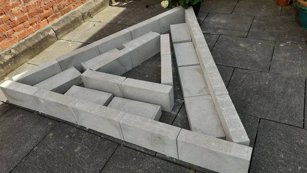 |
| The very beginnings of a true Community Project in Middlewich. This triangular bed is the basis for a floral tribute to Her Majesty Queen Elizabeth II on the occasion of her Platinum Jubilee in June. The floral feature is being constructed at the URC in Queen Street, Middlewich. All building materials have been kindly donated by the local branch of JEWSON. |

 |
| The 2nd Middlewich Brownies lend a hand with the project on Thursday 19th May. |
 |
| All hands to the paintbrushes! |
3.jpg)

 |
On Friday 20th May it was the turn of members of the local Boys Brigade, which also meets at the Institute, to lend a helping hand. Willing volunteers helped put bags of builders sand, donated by Jewson, into the flower bed to form a basis for the compost and topsoil to follow. Lynne Hardy writes:
Special thanks to: Steve Dewhurst Lyndsey Devaney Alan Bourne Next-door neighbour John .svg.png) For further information on the Middlewich Boys Brigade, please click here
Middlewich United Reformed Church website UPDATE Wednesday 25th May 2022  Almost there! Our special jubilee flower feature is nearly complete, with the addition of compost and topsoil kindly supplied by Morrisons, Middlewich and Katie Mulhern of Middlewich Crazy Daisies. The actual flowers will appear in the next few days. UPDATE Tuesday 31st May 2022  This is the next step. Once all the planting has settled in, bushed and spread out and come into bloom you will all enjoy seeing it on the front of United Reformed Church. A special thanks to Brian Lowe of Spark Lane Nursery for his expertise and generosity. This has truly been a community project with local firms, people and organisations being involved.  Many thanks once again to all the many people who have contributed to this project. We will be bringing you updates as the flower bed fills out and develops. First published 18th May 2022 |

Introduction
by David Roberts, Editor.
The Middlewich limebeds, seen by most people as a large embankment alongside Booth Lane and the Trent & Mersey Canal, have long been a source of interest and speculation for the people of the town. They provide a very unusual environment, quite unlike anywhere else in the town, and many people have, over the years, wondered if that weird and wonderful man-made world could, in some way, be used to the advantage of locals, for wildlife conservation and as an area for leisure pursuits (it has, of course, long been used unofficially for the latter purpose).
The trouble with that idea, of course, is that an unstable mixture of chemical waste, coke and cinders, together with the salt waste contributed by British Salt, is hardly the kind of basis most would consider suitable for a picnic area.
More radical ideas have also been proposed for the limebeds over the years, including their complete removal to form yet another site for new housing. The area's proximity to the Trent & Mersey Canal has raised dreams of marinas, waterside restaurants and the like.
But - if you were to remove all those thousands of tonnes of waste, where would you put them? And just how hazardous would it be to do it? And what would happen to the flora and fauna which lives in the area?
Some refer to this area as the 'salt lagoons', a reference to the fact that when British Salt opened to the South of the site in 1969, the lime beds were used for the dumping of waste from the salt making process. This dumping commenced sometime after 1973. Instead of pipelines British Salt used dumper trucks to transfer its waste to the limebeds, which necessitated the bulldozing of the original rather picturesque path through the site into something resembling a road.
The 'Jubilee Train' referred to by Frank was a small diesel (or petrol) driven loco hauling tiny dumper trucks which tipped clinker, cinders, ash and 'lime mud' over the edge of the limebeds, strengthening those walls as it went. Particularly memorable to me as the train was driven by my 'Uncle' Amos Hodgkinson. Sadly I only saw the train and the little railway after it had fallen into disuse.
You'll note that, from time to time, Frank refers to aspects of the lagoons which 'may be of interest to British Salt'. Possibly at the time the article was written, the company was assessing the lime beds for future use?
 |
| Poppityjohns in 1973, before the British Salt bulldozers changed it forever. In the background can be seen, on the left, No 1, The Villa, in Cledford Lane, the home of the Farrington family at that time. To its right is the British Salt works, then only four years old. The brick chimney was part of Steventon's Pottery Works, later Ideal Standard, which was on the site now occupied by the ANSA waste recycling depot. |
In fact, 'lagoon' is the correct term, and one that Frank uses in his article.
The Griffith's Road Lagoons at Lostock, near Northwich, are still in use and still used for their original purpose. There have, over the years, been other limebeds in Middlewich. which is inevitable when you think of the various chemical works there have been here over the years. For instance, there was, up until the late 1970s, one in Brooks Lane, close by the three locks. There are (or were) also limebeds at the former ICI works at Winnington.
The public footpath which runs through the limebeds is known as 'Poppityjohns', a name whose origins are unknown, though it's thought that it may be a corruption of 'Poverty Johns' or possibly 'Property Johns', a reference to someone who once owned the land.
If you want to establish your real Middlewich credentials, just tell everyone you're going for a walk 'across Pops'.
In the early 1970s, when ERF Ltd established its service centre on part of the old ICI site and turned the northern end of Poppityjohns into the ghastly 'Road Beta' (an address they never actually used), Middlewich UDC Surveyor Donald Stubbs, who was a great upholder of Middlewich tradition, insisted on erecting a sign at the foot of the limebeds with the original name on it. The sign was only there for a short time, so we're lucky to have a photo of it.
 |
| The short-lived Poppityjohns sign in 1973. Does it still exist somewhere? The limebeds are in the background, and the public footpath can be seen climbing up to the left. The fence belongs to ERF's Service Centre which had been built on part of the ICI site two years earlier. |
Frank himself describes it as 'a paper' and it's in the tradition of such dissertations, assuming that the intended audience has at least a little knowledge of the subject. There are some technical matters which may go over the heads of many of us. However, it's very accessible and answers many questions about this fascinating part of Middlewich. Additional information, in brackets, comes from my own (limited) knowledge.
If you should fancy following in Frank's footsteps and taking a look at the limebeds as they are today, please remember that this article was written twenty six years ago and in it Frank is remembering even earlier times. Much has changed. In particular, as can be seen from our title photo from Google Earth, vegetation has encroached on a lot of the area. And bear in mind also that much of the limebeds is private property and can be a treacherous and dangerous place to be.
ICI WASTE LIMEBEDS
by Frank Smith.
.jpg) |
| The source of all that chemical waste. ICI Middlewich. The limebeds were (and are) out of shot to the right. This is a souvenir photo given to all ICI employees when the works closed in 1962. Photo restoration by Bill Armsden and John Bailey. |
For the purpose of this paper assume that the limebeds run North to South, bounded on the East side by the Sandbach-Middlewich-Northwich railway, on the West side by the Trent & Mersey Canal, on the South side by Cledford Lane and on the north by the ERF workshops and research buildings (ERF is long gone, but the buildings are still there, and still in the motor trade - Ed).
The lagoons were formed to accommodate the Distiller Blow Off liquor, usually referred to as D.B.O. This consisted of a clear liquid (Calcium Chloride) with various and varying calcium compounds and minute pieces of coke and cinder from the lime kilns. In the lagoons the sediment settled on the bed and the Calcium Chloride ran off as a clear liquor to discharge into Sanderson's Brook (Sanderson's Brook is a small stream which flows down from the Bradwall area to meet the River Croco near Brooks Lane. The Croco then flows alongside the T&M Canal through Middlewich to join the River Dane at one corner of Harbutt's Field, near the Big Lock. Calcium Chloride was far from the only pollutant to be chucked into poor old Sanderson's Brook and the Croco over the years - Ed.).
To me the 'old' limebeds lie to the East side, as they had acquired a sparse coating of grass and were home to numerous peewits and skylarks. There were also a few scrubby bushes of a variety of willow.
The beds seem to have been raised at different periods, since their inception, possibly while they were 'resting'. Initially the lagoons were built with clinker walls on the outside, with a backing of ashes. Thinking about this, the walls could have had an inner clinker wall with an infill of ashes, the whole thing being wide enough to allow the passage of horse-drawn carts to carry the materials used to raise the walls. The clinker would be supplied from the Finishing Machines (Chemical Roasting Furnaces) which converted the Sodium Bicarbonate at high temperatures. The fine ashes would come from the Babcock & Wilcox boilers used to raise the steam for the turbines and the chemical process.
It is interesting to note that later limebeds on the top of the old East limebeds did not have clinker walls; possibly the building of clinker walls was found not to be economically viable, but were built with cinders or earth. About this I am not sure, as these banks were grass covered. Core sampling could answer this.
On the 'new' limebeds on the West side: these may be of more interest to British Salt; I recall that the 'Jubilee train' hauled bogies of clinker and ashes along the top of the walls and discharged them down the outside of the walls. Thus the later walls relied on the natural 'slump' of the material to form the angle of the walls. I have a feeling that the bed of the Jubilee track was made of limestone chippings (2" to dust).
The D.B.O. liquor was distributed to the lagoons along wooden troughs formed in 'U' section with 9" x 1½ " boards with the angles filled with triangular wooden fillets.
A worker was employed maintaining the limebeds. He removed gritty sediment from the troughs and spread this along the top of the walls. This dried out to become reasonably firm, perhaps due to rain washing the Calcium Chloride out of it.
A further waste product was used to a lesser degree in the construction of the walls. The burnt limestone from the kilns was dissolved in water in an almost horizontal rotary vessel. Any unburnt stone and grit was sieved out, the larger pieces returned to the kilns and the remaining grit and small pebbles of limestone, together with some lime mud, was sent in bogies to the lagoons. This was tipped down the face of the wall and eventually set quite hard. An example of this can be seen on the South wall of the West bed on Cledford Lane.
In 1939, just prior to WWII, the direction of the path across the limebeds was altered. Before this time the path ran in a straight line from its present entry at the North end to No 2 Brine Shaft where it picked up the present path southwards. This was a sunken path and the east side carried the brine main from the shaft to the works. Just East of the brine main, and higher, ran the D.B.O. trough on trestles. By blocking off the ends of the sunken path it was easy to increase the size and capacity of the West lagoon at little cost.
On the top of the wall slightly North West of No2 Brine Shaft I recall, some twenty years ago (circa 1976 - Ed) finding a variety or orchid which I also found growing on the old Furey Limebeds at Winnington.
 |
| The limebeds in 1973. In the background can be seen British Salt, and the redundant chimney at Ideal Standard which was demolished not long after this photo was taken. In the foreground is one of the walls of the limebed along which the narrow gauge train ran, tipping waste products into the lagoon. |
Just before the ICI had completed its tests on utilizing the empty borehole cavities on the brinefields at Holford for the disposal of D.B.O. mud (this site is between Middlewich and Northwich, and has an entrance on King Street. Many of the brine cavities are currently being used by INEOS to store natural gas. The brine for Middlewich's British Salt works comes from Warmingham - Ed) they were in the process of constructing new limebeds at Dairy House Farm, Marbury (the result of this construction on the landscape can still be seen today. Please follow this link - Ed). The walls had been built around a field when work stopped. These walls still stand and may be of interest to British Salt. (Here Frank has been overtaken by events, and British Salt wouldn't have been able to consider using the site if they wanted to. The site was bought by Cheshire County Council and developed into a leisure facility - Ed).
Seepage through the walls of the limebeds was dealt with by an open drainage ditch round the whole area, discharging into Sanderson's Brook from the North end. It is possible there may be a drain at the South end, passing under the railway bridge on Cledford Lane and discharging into Sanderson's Brook below the road bridge.
In the 1950s ICI had complaints that Calcium Chloride was polluting the wild brine stream and it was attributed to No 2 Shaft. This was examined by a joiner who was lowered down the shaft in a tub. A similar tub is in the Salt Museum in Northwich! (Now the Weaver Hall Museum - Ed)
He inspected the whalings* around the side for leaks and also tested them for decay by trying to insert a knife blade into the timber.
*this is the one problem I've had with Frank's handwriting which, as you can imagine, is always neat and very legible. I can't find a definition for 'whaling' other than the one you'd expect. He's obviously referring to the wooden lining of the brine shaft and 'whaling' may be a term used exclusively in the chemical and/or salt industries. I can't think what else the word can be. We're sticking with 'whalings' for the moment, but if anyone knows differently, please let us know. - Ed.
The whalings were found to be sound and with no leakage. The soundness of the timbers could possibly be due to the chemicals inhibiting bacterial and fungal activity.
The whole area of the top of the shaft was covered with a concrete capping with an access manhole in the centre. This, in turn, had a locking bar across it.
The site was visited by the Outside Foreman from ICI Holford brinefield on a six-monthly basis to ensure that it was in a safe and good condition. The liquid that accrued in this area drained into the ditch at the South end of the 'old' East limebeds. In the vicinity of the shaft is a tall, circular, brick construction, mistakenly thought by some to be a brine shaft. It is an inspection manhole for the drains at ground level and has been extended as the limebeds were raised. There is a further, similar, manhole by the present path nearer the North end.
The open ditch at the South end of the East lime bed continues, or starts, under the road at the West end of the ditch and can be walked in under the road. This is most probably the surface drain from the shaft.
Frank Smith
Ravenscroft
29th July 1996
Post Script
Since writing the above I have looked at Ordnance Survey maps dated 1909 and 1954. On the 1909 map the 'new' West limebeds are not shown and are fields. On the 1954 map the West limebeds are in existence, together with a long narrow bed on the West side and running the full length, North to South, of the limebeds. On reflection I think that this narrow bed would have to be built at the same time as the main West limebed to have access for the Jubilee train to raise the walls. I can only surmise that its purpose was to act as a 'buffer' in the event of a wall collapse or a large leak. The risk of flooding the Trent & Mersey Canal would be minimised as the main limebed would not drain into the small bed.
The land at the South end of the West bed belonged to EB & BP Ltd (Electro - Bleach & By-Products, the chemical company which stood on the Cledford Lane site later occupied by Steventon's/Ideal Standard and now the home of the ANSA recycling facility - Ed) and the limebed wall adjoining the property collapsed and flooded the field. Cynics said that it was an 'engineered' accident to enable Brunner Mond & Co (later to become ICI Ltd - Ed) to extend their limebed.
As I am now unable to verify if this occurred before 1920, when Brunner Mond acquired EB & BP, I don't know how true this is.
F.S.


