Saturday, 3 November 2018

PEPPER STREET , EARLY 1969 (2)


Once again we find ourselves in Pepper Street in 1969 with a picture which should help to make the layout of things clearer.
(The white 'flashes' to the left, by the way, are caused by damage to the original Kodachrome film, illustrating all too clearly why we need to preserve this collection wiihout delay). The houses to the left are what now makes up modern-day Pepper Street. For the first time, at the end of the row, we can see the side wall of Seddon's office building. On the right of the picture is the end of the row of cottages which have been replaced by our famous 'grass verge'. What's the building to the left of them with the tall, central chimney, just above the Robin Reliant?


This photo was first published on Facebook on 26th April 2011. 

The original Facebook feedback is below:


Geraldine Williams Oh yes! that side wall of the Seddon's offices was the perfect place to hone one's twosie, or even threesie, tennis ball skills! Not sure about the other building. Some demolition had obviously taken place where the chain-link fencing stands (and the forlorn figure sits!) so it's a bit out of context for my recollection.

Dave Roberts I've been waiting for someone to tell me it's not a Robin, but a Regal Supervan or something.
Colin Derek Appleton Is that building the pub that was called the Lord Hood ?

Geraldine Williams
Yes, according to Google.


(Editor's note: In fact subsequent research indicates that the Lord Hood actually stood on the waste ground where the Reliant car (can be seen).

Colin Derek Appleton Cool! cant take all the credit though, my dad told me the locations of all the vanished pubs when i was a boy !!

Geraldine Williams I understand that the pubs near the salt works used to open at 5.00am to enable nightshift workers to re-hydrate after working on the open pans.

Colin Derek Appleton That's very possible. My Grandfather worked on the pans in the Pepper Street works as well as working for Seddon on his fleet of boats.

First published 10th July 2011

Reformatted and re-published 3rd November 2018

Tuesday, 30 October 2018

PEPPER STREET/LOWER STREET JUNCTION, EARLY 1970s

If you own the copyright on this photograph, please let us know


Looking almost impossibly narrow and confined, this is the junction between Pepper Street and the area where Lower Street became Wheelock Street. It's very early in the 1970s - quite possibly 1970 or 1971.
In fact it's rather difficult to say which particular street Pepper Street is joining here - Wheelock Street is to the right, and Lower Street to the left.
Perhaps it might be more apt to say that this is where Pepper Street meets The Bull Ring.
Across the road is the then brand new building built by the Co-operative Wholesale Society Ltd and known as the Co-operative Superstore, reflecting its purpose as a place where all the previously scattered Co-op departments in Middlewich were, for the first time, gathered together under one roof.
It's rather disconcerting to note that the shop's entrance wasn't always on the left hand side, as it is now that Tesco Express rules the roost there. The right hand part of the building,  occupied for many years by Pineland Ltd, was at this time the Co-op's chemists department.
The windows in the building on the left belong to the flat above Vernon Coopers' Radio, TV and electrical shop, and the brick wall on the right was part of the house next to Dewhurst's butchers shop.
This junction, together with the reverse side of that ridiculously tall (for sighting purposes) STOP sign can be seen in this entry
VERNON COOPERS, STANWAYS AND WOODBINES

as it appeared from a camera position looking in the opposite direction from just underneath the Co-op's long vanished canopy.
As Seddon's Salt Works was in Pepper Street it might be thought that this cramped and inconvenient junction might cause problems for vehicles wanting to reach the works but, in actual fact, the entrance and exit for carts (and later lorries) taking loads of salt from Seddon's was further down Lower Street, next to the gas showroom near Town Bridge.

FROM WEBBS LANE TO LOWER STREET VIA PEPPER STREET


FROM WEBBS LANE TO LOWER STREET VIA PEPPER STREET

by Dave Roberts


As might be expected, the original Diary entry
 'Pepper Street/Lower Street Junction Early 1970s' has attracted a lot of interest since it was first published in 2012. 

We thought it might be worthwhile trying to illustrate how the old, longer, Pepper Street used to look and how it gave people coming from Webbs Lane access to the town centre. 

This photo is as good a place to start as any, particularly as it shows the houses which now constitute practically all of modern-day Pepper Street. Here's the original description of the photo as it first appeared on the Middlewich Diary.

Our favourite contributor, 'Anonymous', said, in relation to our original diary entry which featured this photo:


'This brings back memories. If you were to turn around and walk back towards Webbs Lane, there was an open space opposite Seddons Salt Works. We use to play football and cricket there.'


Well, we think the space to the right of our main picture, where the Reliant car is parked, must be the space in question.

This picture, taken in 1969 with our trusty Instamatic camera, is fascinating as it provides a link between the Pepper Street of those days,at the very end of the open pan salt works era and the Pepper Street of today.


The building to the right with the single chimney is interesting.

Previous MD feedback seemed to suggest that it was once The Lord Hood public house, but this is not the case.

Ken Kingston's Middlewich Hospitality (Middlewich U3A Local History group 2014) tells us that the pub, built in 1782, was closed and demolished in 1920, and replaced by a workshop and timber shed in 1929. These premises were themselves demolished just after World War II, so it appears that the waste ground itself was the site of the pub and its later replacement. What the building with the central chimney was remains a mystery.


Today's street is, as we've said, more or less just that short terrace on the extreme left. What used to be the roadway is now a slip road connecting Webbs Lane to St Michael's Way opposite the Vaults.

The large building at the end of the Terrace is Seddon's Salt Works offices.


Seddon's offices in Pepper Street in the 1920s. The still extant terraced houses can be seen behind the building.

 Beyond that is the salt works itself, by this time closed and awaiting demolition.

Here's what the other side of the street looked like:


To get to the town centre you walked towards the salt works, and then took a sharp right turn between the works and the building beyond the Reliant car to wind up in the Bull Ring. 

Middlewich's automatic telephone exchange, built in 1967 and now much expanded and fronting onto St Michael's Way, was in a small compound, just out of shot to the right.


Powell's Clothing Factory, connected with the company's retail premises in Wheelock Street, could also be found in the area, on land now occupied by St Michael's Way. 

It is this connection with the textile industry which has led to the new housing development next to the telephone exchange being given the rather fanciful name 'Spindle Whorl'. Put simply, a 'spindle whorl' is one of the many tools used by cloth weavers. It's a kind of flat disc with a hole in it. Spindle whorls are made from many diffferent materials and are very collectable.

Another development on the site, closer to Wheelock Street, has been given the more prosaic and, some might say, more appropriate name of 'Powell House'.


Powell's Tailors itself, once the smartest shop in the town, is now in a semi-derelict state after  Eric Alcock electrical moved out a few years ago.


Eric Alcock Ltd, pictured in 2012. The electrical goods firm's tenure of the former impeccably smart Powell's Tailor's premises did its appearance no favours at all, and now (2018) the shop is in a semi-derelict state and looks even worse.


Here's a bit more of 1969 Pepper Street, taking us further towards the town centre:


To get to the town centre today you have to take more or less the same route, but you'll be walking towards the entrance to 'The Moorings' rather than the salt works and, once you make the right turn, you have St Michael's Way, with heavy traffic heading to and from the M6, to contend with before you can reach the Bull Ring.

First published 2nd March 2018
Revised and re-formatted 30th October 2018


VERNON COOPERS, STANWAYS AND WOODBINES 1970

Another excellent shot from the camera of Jack Stanier and a companion shot to the one shown here. It's 1970 (as evidenced by the 'Back Home' World Cup poster in Vernon Coopers window). To the right of Vernon Coopers is Stanways fish shop with its lettering removed but the name just about still visible. Adjoining this we can get a better view of an establishment we've mentioned a few times before - Harold Woodbine Ltd in its original Lower Street premises. It's obvious from the configuration of this shop that it was once  separate premises; probably two or three small cottages. Note that while Vernon Cooper promotes the virtues of Ferguson and Ekco sound and vision, Harold Woodbine favours Philips.
Vernon Cooper advertisement from the Northwich Chronicle of Saturday May 16th 1953, urging people to buy a TV set in time for the Coronation which took place on June 2nd. Note that the address is given as 'Wheelock Street, Middlewich' and that there were also Vernon Cooper shops in Winsford, Crewe, Sandbach and other local towns
Here's a little reminiscence from me about Harold Woodbine's which featured in an earlier posting:

I still remember the excitement when I called in to order a record album in 1963
(actually, we didn't call them 'albums', we called them L.P.s)
The record seemed to take weeks and weeks to arrive but when it did, I played it
until the grooves were white with wear. It was 'With The Beatles'
(the mono pressing, of course). A year earlier my eldest brother, Glynn,
had brought home 'Love Me Do'. The perfect ending to this story would be
for me to say that I thought this early 'waxing' was great, but I didn't.
I thought it was boring. By the following year I'd obviously changed my
mind about this Liverpool beat combo. (original comment from Facebook)

Moving to the extreme right of the picture we can see the very edge of the Town Hall complex of buildings and, to the left of that, the JayGee Fireplace building which is now  Town Bridge Estate Agents. Left of this is the North-Western Gas Board showroom and, to the left of that, the first signs of demolition along the row as the showroom manager's house is reduced to rubble.
To take this picture Jack stood outside what is now Pineland*. If we were to take a picture from this viewpoint today we'd see mostly dual carriageway with the Bullring bus interchange to the right of it. (see 'Now & Then: The Bullring . Link below).
There are a few interesting little details about Vernon Coopers shop which will replay a bit of clicking and double clicking: First of all, above the 'Ltd' on the left hand side is a small sign directing people down Pepper Street to The Vaults and its car park. Secondly, what might appear at first to be a satellite dish on the left hand wall is, in fact, a STOP sign for the Pepper Street/Lower Street junction, placed at this height to make it visible from further down Pepper Street.
And if you look to the left hand side of the building's tall chimney, there is a fine array of vintage VHF TV aerials. The giant X is for band one, BBC 1 on channel 2 and the other, classic 'ITV' aerial is for band three, Granada Television on channel 9. Incidentally, if you should happen to have a surviving ITV aerial on your roof, you could use it for receiving DAB radio, as the aerials are exactly the same. Somewhere, by this time, there must also have been one or more modern  aerials for 625 lines UHF (with colour on all three channels).

* Update: Pineland has now joined the long list of closed businesses in Middlewich (Sept 2014)

See also: LOWER STREET 1970
               LOWER STREET 1969
               NOW and THEN THE BULLRING
               PEPPER STREET/LOWER STREET JUNCTION EARLY 1970s

Facebook feedback:

Ian Hill-Smith What's the road leading out of the right of the pic, Dave?

Dave Roberts Hi Ian. The road in the right foreground is Hightown which is still more or less in the same position, although the traffic flow now runs in the other direction - i.e. towards Lewin Street, The road leading off into the distance (and the Town Bridge) is now the bus lay-by and part of St Michael's Way.

Originally published on 1st September 2011
Re-formatted and re-published 30th October 2018

Sunday, 28 October 2018

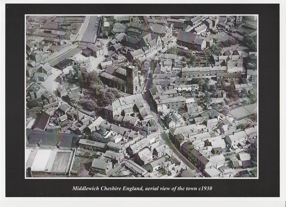
1930s AERIAL VIEWS OF MIDDLEWICH


by Dave Roberts

We're grateful to Dave Griffiths who contacted us in September this year with the news that a set of four aerial views of 'Middlewich in the 1930s' was being offered for sale on Ebay.

Dave couldn't resist the temptation, and bought all four photos.

He's kindly sent us copies of them so that we can show them to a wider audience and give people just a taste of how Middlewich looked no less than eighty-eight years ago (or more).

We've already encountered a couple of these photos over the years, but never before in such high quality.

English Heritage's Britain From Above website*, which features aerial photos of towns and villages all over the country, carries copies of at least two of them and, a few years ago appealed for people to contact them with information as to what they showed. 

Which is what the Middlewich Diary did in respect of the Webb's Lane/Finney's Lane view (see below).

You'll note that these views are all labelled 'c1930' and this is an approximation which we'll gladly go along with for a couple of these photos. But for two of the photos we think the date may be earlier than that, for reasons we'll explain as we go along.

And so to the first photo (above). Nearly ninety years on (or perhaps even more), but still recognisable as the Middlewich we know today. Our reference point, as always, is the Parish Church of St Michael & All Angels.

We sometimes hear complaints - and tend to agree with them - about the number of trees in the churchyard today, tending to obscure the building itself from some viewpoints. 
This old photograph shows us that this is nothing new. It should be remembered that at the time of the photograph the churchyard had been disused as a graveyard for many years, the last burials  taking place in the 19th century.
So the grounds of the church were, apparently, being left to their own devices at this time. 

The triangular cluster of buildings in front of the church, comprising the old town hall and various shops, was swept away in the early 1970s to make way for first the much-hated 'Piazza' and more recently, in 2005, the 'Amphitheatre'.

The other main change, of course, is the loss of the old Town Bridge and its replacement by a much wider and larger concrete bridge, followed forty years later by the re-alignment of Kinderton Street and the building of St Michael's Way, cutting a huge swathe through the property on the left hand side of the picture.

But most people, of course, will want to know how this photo relates to what can be seen today, and this is probably best achieved by use of a numbered key.

* Unfortunately, at the time of writing, the Britain From Above website seems to be inaccessible.

1: The old town bridge. A traditional 'hump-backed' canal bridge dating back to the building of the Trent & Mersey Canal in the 1770s. Several buildings clustered around the old bridge including the Navigation Inn. The bridge was demolished in 1931 to make way for the present bridge.
The old town bridge, circa 1914. The Navigation Inn can be seen
 in the middle of the photo.

2: Seabank. A road which ran (and still runs) from Kinderton Street down to the banks of the River Croco and the T&M Canal. The footbridge seen here follows the original route from Kinderton into Middlewich (before the coming of the canal there was a ford across the River Croco at this point). 

In medieval times, salt houses belonging to the Barons of Kinderton were clustered around this area. The remains of the footbridge, which disappeared when the new town bridge was built,  can still be seen in the form of blue-brick abutments on both sides of the canal.
The building just below the footbridge is a canal warehouse, part of the Middlewich Town Wharf group of buildings. The only other surviving building now is the Wharfinger's Cottage below the warehouse and slightly to the left. 

The people of Middlewich would dearly love this area to be developed and turned into an attraction for the many boaters and other visitors to the town each year. 

There have been suggestions that the buildings could be used as restaurants, museums, laundry facilities for boaters and so much more.
Unfortunately the whole idea of developing the area as the 'Gateway To Middlewich' seems to be blocked by whoever it is who now owns the land.
No progress has been made in bringing the idea to fruition and the buildings are steadily getting more dilapidated with each passing year.

3: The huge buildings fronting onto Lewin Street shared this site, between the road and the canal, with Seddon's Wych House Lane Salt Works and its associated wagon repair shop. The main buildings were the Church of England Infants' School and the Wesleyan Methodist Chapel. 
Everything on the site was swept away during the 1970s and 1980s and the site is now occupied by the Salinae Centre and its grounds.

4: Across the road was another large building, and one we haven't yet covered in the Middlewich Diary, due to a lack of information. The Congregational Centenary Sunday School (below) shared this site with the Conservative Club and Heathcote's Cafe.

There was a chronic shortage of space in Middlewich's schools after the First World War and the Sunday School was used as an 'overflow' for the CofE School across the road.

In the late sixties this building was used as the local valuation office. 

Middlewich Library now occupies the site.

5: Lower Street and Hightown. Now occupied by the 'amphitheatre', with the war memorial on a strip of land between the amphitheatre and the churchyard.
The original site for the memorial, erected in 1934, was at the apex of the triangle formed by these buildings, replacing a shop which did service both as a butcher and as a branch of the National Provincial Bank. Oddly, though, the bank preceded the butcher's shop. For some reason, I'd always assumed that it was the other way round. The whole area is also known as 'the Bull Ring'.

The angled building at the rear of the site is the old Victorian town hall. When the new town bridge replaced the old in 1931, Lower Street was widened by slicing off a section of the old churchyard. The part of the town hall fronting onto Lower Street was also removed to enable this work.

A section of what was Lower Street survives in the form of the lay-by used by buses and taxis in front of the 'amphitheatre'.

6: This is where we tentatively part company with the date of 'c1930' for this photo. According to all the information we can gather, the butcher's shop on Hightown which we immortalised as The Butchered Butcher's Shop and which is now a Chinese takeaway, was built in 1920 (the same year as the Alhambra Cinema, local 'historians' might like to note) but there's no sign of it here. It is, however, possible to see that one of the buildings on Hightown has recently been demolished, and we think it's possible that this is the site of the butcher's shop. If this is correct the shop to the right of the demolition is the site of what was until fairly recently the NatWest Bank (Allan Earl in Middlewich 1900-1950 (Cheshire Country Publishing 1994) mentions that in 1920 '...the construction of the new bank in the Bull Ring was well on the way').
So that would put the date of this photograph a decade earlier at c1920.

 If you think we're wrong, we'd love to hear from you.

7: Queen Street. The old police station. Like so many old Middlewich buildings this disappeared in the 1970s, to be replaced by a small brick box looking like many other identikit stations around the country. 

Note the terraced houses stretching from the police station towards Hightown. In the street's days as 'Dog Lane' many more tiny cottages were to be found here.

8: The oblong tanks are salt pans and are  part of Seddon's Pepper Street salt works. Unlike most such pans, they're out in the open air and they were used for the making of fishery salt, used in the preservation of fish and meat.

9: The site of Cooper's (formerly Kinsey's) shop. Approximately the site of the current Tesco Express store.

10: Brown's Vaults (now simply 'The Vaults') and Dewhurst's butcher's shop.
At the very end of Pepper Street which, at that time, connected Middlewich town centre with Webbs Lane. Until the early 1970s The Vaults was hidden away behind Dewhurst's, which was demolished to make way for the current pub car park.


The same view from a slightly different viewpoint. More of Seddon's Pepper Street works can be seen in the left foreground with the Trent & Mersey Canal which served it on the extreme left. Pepper Street can be seen running past the works in the middle foreground.

Towards the top left you can see the cluster of buildings around the old town bridge, then the Seabank footbridge.
Just above and to the right of the footbridge is Seddon's Wych House Lane works. and, right at the top, the bottom lock of the Brooks Lane flight. 

Top right, Lewin Street continues, to become Booth Lane on its way to Sandbach.

Pepper Street, early 1969.

Finney's Lane and Webb's Lane. We have already covered this photo in the Middlewich Diary and full details can be found here. You'll note that when we originally published this we took an educated guess at the photo dating from the 1920s. Could it be that this photo, too, is earlier than we first thought?

This one is new to us and is very much of interest because it shows the Electrolytic Alkali Works in Booth Lane, the  site of which has very controversially been in the news in recent years as the home of Cheshire East's new waste recycling facility. If this photo was indeed taken in 1930 the works must have  just closed.

(Photo: Cheshire Image Bank)

This was one of the sites that Edwin Richard Foden looked at in 1933 for the manufacture of the E. R. Foden diesel-engined lorry, better known as the E.R.F. 

So the Sun Works,  Sandbach could very easily have been the Sun Works, Middlewich, had things turned out differently.

As it was, of course, the site  became a pottery works owned by Steventon's and later Ideal Standard, manufacturing bathroom equipment.

A last-ditch effort to keep the factory going as a pottery manufacturer was made by OURS Bathrooms, but the operation closed completely in  2013. 

The Trent and Mersey Canal runs from bottom left to middle right and the old Cledford Lane canal bridge, replaced in the 1960s by a modern structure, can be seen just below the office block, the remaining portion of which is just about the only part of the original works still in existence.

Cross Lane comes in from bottom right and that distinctive double-ended building gives us our present day bearings, but many of the present day housing in Booth Lane, Cross Lane, Cledford Crescent and Hutchin's Close has yet to be.

That thin grey line running from left to right in the top part of the photo is the Sandbach-Middlewich-Northwich railway line.

This stretch of road has for many years been the site of salt works. 

Just out of shot to the right were at various times the works of Verdin Cooke, Bowfields and the Middlewich Salt Company (later absorbed into Cerebos Ltd). 

The tradition, of course, continues to this day with the British Salt Works, built on part of the Verdin Cooke site, providing much of the country's requirements for salt.


Many thanks to Dave Griffiths for sharing these fascinating photographs. As always, we're always open to correction and love to hear alternative theories as to what we might be looking at in this type of photo.

Please don't hesitate to get in touch if you think you can help set the record straight!

Dave Roberts
Editor.


Monday, 22 October 2018

MIDDLEWICH LAMP-POST POPPIES 2018. A THANK YOU.

Margaret Scarlett writes, on behalf of the Royal British Legion, Middlewich branch


The Middlewich Branch of the Royal British Legion would like to thank all their sponsors both business and personal, for the wonderful display of poppies on lamp-posts throughout the town.

Many thanks also to  SP Energy for placing the poppies on the lamp-posts. 


The presence of the poppies impressed both residents and guests at the recent unveiling of the WW1 fourteen  extra names on the War Memorial, and helped in enabling Middlewich to show its respect for members of the armed forces,  past and present. 

Thank you all for helping the town to commemorate Remembrance in this way.


Margaret


Friday, 19 October 2018

LAWRENCE AVENUE 1969


One of those street scenes in which nothing really seems to have changed much but which, on closer examination, has altered considerably. In 1969 Lawrence Avenue was one entity - an unadopted road linking Wheelock Street with Webbs Lane. The coming of  St Michael's Way in the early 70s cut the Avenue in half and necessitated the demolition of several properties, including the white building in the middle of the picture, and a huge wooden fence cordoning it off from the new dual carriageway. The buildings in the foreground of our 1969 shot are now part of Lawrence Avenue West and those beyond St Michael's Way constitute Lawrence Avenue East. Note the elegant swan necked concrete street lamp. This was still in existence in 2011 and a similar specimen once graced Seabank.*
The building on the extreme left is now Brooks & Bostock Jewellers Shop, a block of new garages has been built on the right, and there have been various other changes on the Lawrence Avenue scene.
Nowadays, for many people, the words 'Lawrence Avenue' mean only one thing - a trip to the dentist. I'm one of them and I'll take the opportunity of my next check up to procure a modern day version of the scene for a 'Then & Now' feature.


But there's more to Lawrence Avenue/Lawrence Gardens than meets the eye. When this posting was first written I made the assumption that Lawrence Avenue was named after Charles Frederick Lawrence, the late Middlewich historian and Clerk to the Council. But it was Charles Frederick Lawrence himself who made Neolithic discoveries in 'Lawrence Gardens', so the name predates him.

And there are records of people from Lawrence Gardens buried in Middlewich Cemetery going back long before CFL's time. But when did Lawrence Gardens become Lawrence Avenue?
See Facebook Feedback below. -ed


Photo: Middlewich Heritage
Society
Charles Frederick Lawrence was born in 1873 and was, from a very early age, interested in the history of Middlewich. After being employed at several local firms he became clerk to the Urban District Council in 1904. He retired in 1938 and died in 1940.
Among his written works  are 'A History Of  Middlewich' (1895), 'The Annals of Middlewich' (1912) and 'Middlewich Doings In Olden Days (1925). He also wrote  poetry, including anthologies of patriotic verse published by the UDC and sent out to  the trenches during World War I.
'CFL' was a pioneer in Middlewich local history, and one of the inspirations for the Middlewich Heritage Society in the 1980s.
(acknowledgments to Alan Earl for some of this information. A fuller biography of C. F. Lawrence appears on page 55 of 'Middlewich 1900-1950')

*This lamp was replaced by a modern LED lamp on 26th January 2017

Facebook feedback:

Geraldine Williams It always used to be called 'Lawrence Gardens'. When did it get the 'Avenue' status?

Dave Roberts A very good point. And I thought for a moment I'd made one of those embarrassing slip-ups which occur when I rely on my memory. But no - it is definitely called Lawrence Avenue East & West. Was I making an assumption, too, when I said that the road was named after C F Lawrence? According to Wikipedia it was CFL himself who made archaeological discoveries 'in Lawrence Gardens', so the name must pre-date him. These are deep waters, and I sense another epic struggle to get to the bottom of things.
‎...still, we did it with Sharon's cafe, didn't we?
Here's one clue: When the road was sliced in half and the Wheelock Street end became 'Lawrence Avenue West', the word 'West' was added on a separate sign, so it must have been an 'Avenue' prior to the early 70s, if you get my drift.


Geraldine Williams
 Charles Frederick and his wife Kitty's house was actually off Lawrence Gardens, and had a large orchard. If you come in from the Webb's (who were they???!!!) Lane end there's a big house on the right where the Bennion family lived and a bungalow built sideways on (I don't know if it's still there) and this path led on to the Lawrence house. I can just about remember Kitty. She was a St Mary's parishioner.
According to a Google site, Charles Frederick and two other brothers, Augustine and Thomas, were the sons of John Lawrence and his second wife Hannah. John, a joiner/builder lived in Wheelock Street but the 1901 Census shows him being retired and having moved to Lawrence Gardens. Perhaps he built the house there and Charles Frederick eventually inherited the family home.

See also: NOW and THEN: LAWRENCE AVENUE

First published 7th September 2011
Re-formatted and re-published 19th October 2018